River key terms
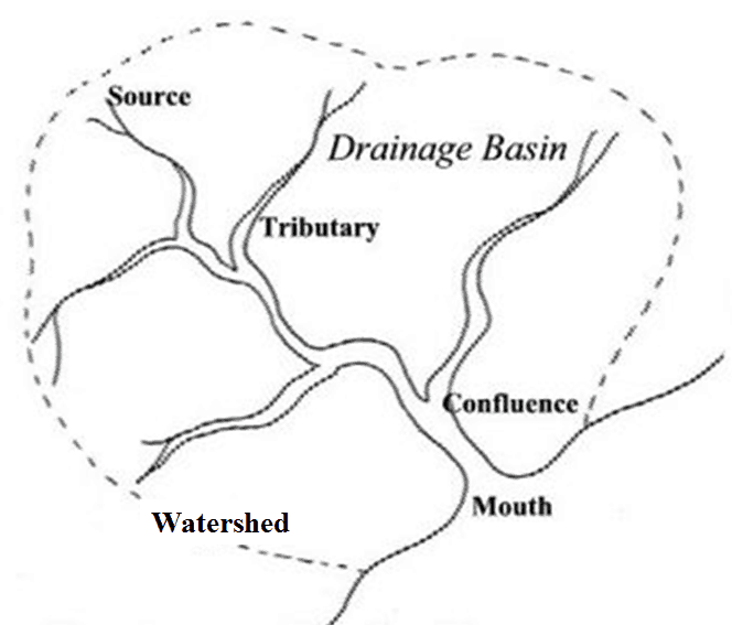
1)Source = start of the river on hill or mountain
2)Tributary = small river which joins a larger one
3)Confluence = where two rivers join
4)Mouth = end of the river where it flows into a sea or lake
5)Watershed = high land which separates one river from the next
6)Drainage basin = the area of land drained by a river
River processes
There are 4 types of weathering
- Freeze-thaw weathering
- Biolgogical weathering
- Chemical weathering
- Onion skin weathering
There are 4 types of erosion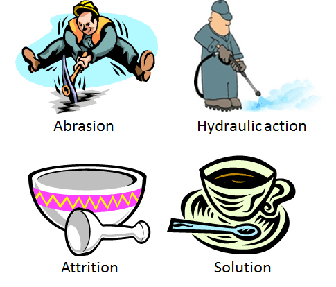
- Abrasion (sometimes called corrasion)
- Hydraulic action
- Attrition
- Corrosion (sometimes called solution)
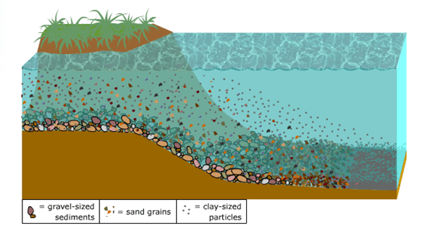
There are 4 ways material is transported by a river
![]()
- Traction
- Saltation
- Suspension
- Solution
Deposition
 As the water in a river slows down it degins to drop – or deposit – the sediment it is carrying. The coasest (or largest) stones are desposited first because they are heaviest. The finest (or smallest) stones are carryied furthest and deposited last. Sediment deposited by a river is called alluvium.
How does a river change as you go downstream?
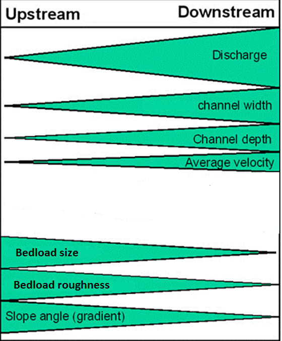
Bradshaw’s Model suggests that a river gets wider and deeper as you go downstream due to erosion. The discharge (amount of water) will increase due to tribuataries joining. The bedload size and shape will decrease due to attrition.
.
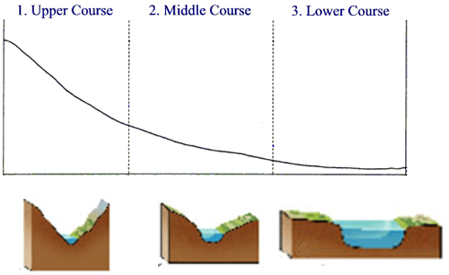
The long profile of a river changes as you go downstream. It is steep near the source and becomes more gently sloping. The cross profile changes from a narrow V shaped valley near the source to a wider and deeper channel near the mouth.
River features
Upper course features
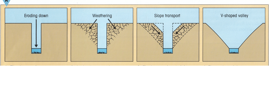 V shaped valleys are formed with vertical erosion by abrasion. The large bedload chips away at the river bed Freeze-thaw weathering weakens the channel sides. The rocks fall down leaving a V shaped valley.
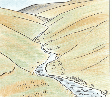
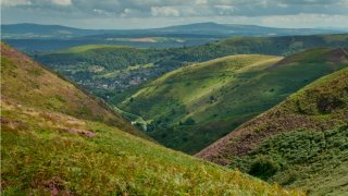
Interlocking spurs are formed when the small river of the upper course meets hard rock resistant to erosion. The river goes round rock obsticles rather than erode through them. This creates interlocking spurs.
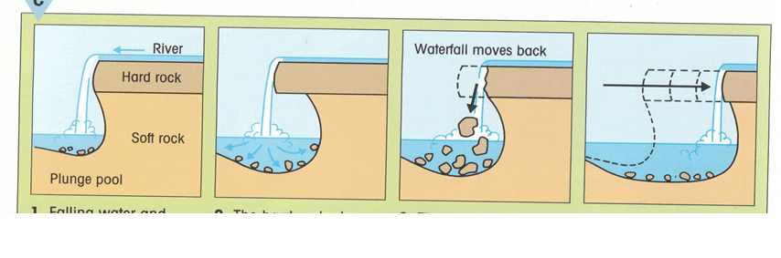 Waterfalls form when a river flows over layers of hard and soft rock. The soft rock eroded by hydraulic action forming a plunge pool below. This leaves the hard rock overhanging. This undercutting eventually leads to the hard rock collapsing and the waterfall retreating.
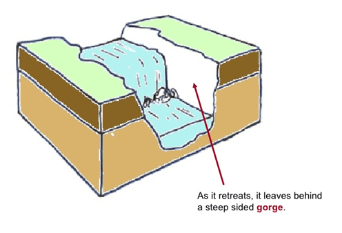
A gorge is formed when a waterfall retreats leaving behind a steep sided valley.
Middle course features
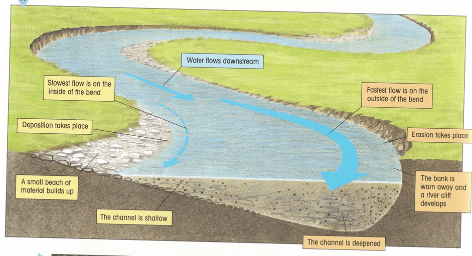
A meander forms when a river turns a corner. The water flows faster on the outside of the bend. This causes erosion by hydraulic action of the outside bank. This forms a river cliff. Deposition occurs on the inside forming a slip off slope.
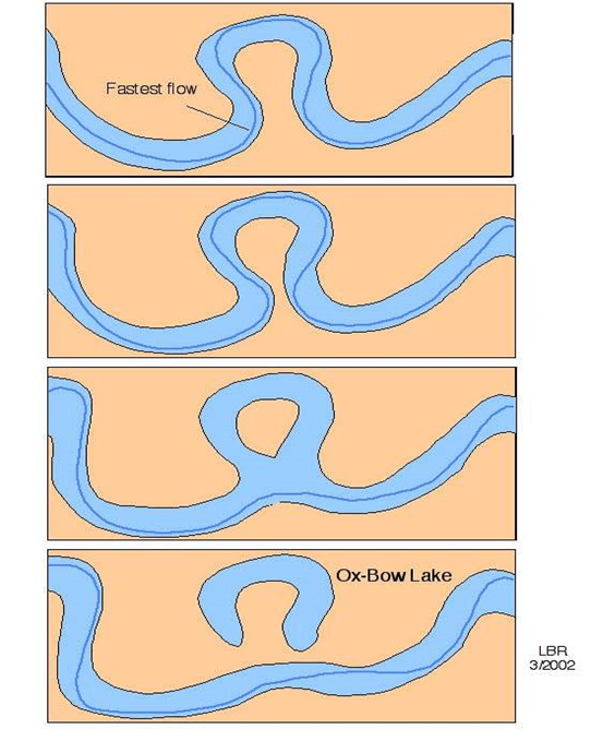
Over time a meander will turn into an oxbow lake. The fastest current (called thalweg) in a meander is on the outside of the bend. Erosion of the river cliff will cause the neck of the meander to become narrow. Eventually the neck will be eroded through leaving a new straighter channel. The old meander will get cut of by deposition leaving an ox bow lake. Over time the ox bow lake will dry up forming a meander scar.
Lower course features
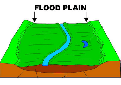
A flood plain forms in the lower course due to deposition. In a flood the river bursts its banks. The flood water spreads out. As the water slows down the sediment (called alluvium) it is carrying is deposited. Over time this creates a flat plain on either side of the river.
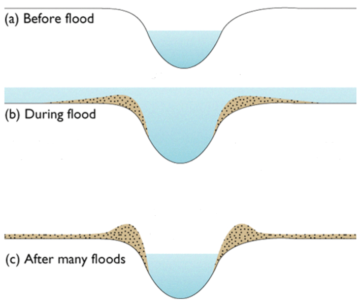
A levee forms when flood waters spread on to the floodplain and slow down. The coarsest sediment is deposited first on the banks. The finer sediment is carried further. This deposition of the biggest stones on the river banks builds up a natural embankment along the channel.
UK river valley example
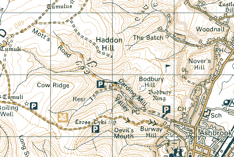
Carding Mill Valley is in Shropshire. It is near Church Stretton in the Long Mynd hills.
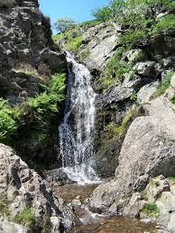
In the upper course of Ash Brook (the river in Carding Mill Valley) there are waterfalls.
 Also evident in the upper course are inter locking spurs.
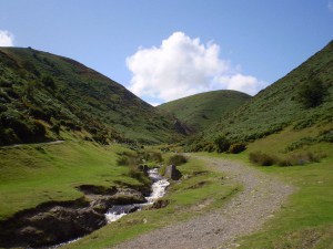
Ash Brook in Carding Mill Valley is a small, narrow stream with large, angular bedload.
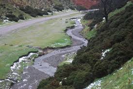 Further down Carding Mill, Ash Brook starts to meander, where you can see slip off slopes and river cliffs.
Flooding

Precipitation – any form of water than falls to the ground
Interception – water caught on the leaves of plants and trees
Infiltration – water soaking into the soil
Surface runoff – water which cannot soak in to the soil but runs over the surface to the river
Throughflow – water flowing through soil to get to the river
Percolation – water soaking into porous rocks underground
Groundwater flow – water flowing through rocks underground to get to the river
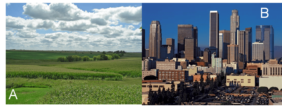 In picture A the rain would be interception by leaves. It would then infiltrate into the soil and flow as throughflow to the river.
In picture B there would be little interception or infiltration. Instead there would be lots of surface runoff.
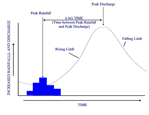 A hydrograph shows how a river responds to rainfall. If the lag time is short it means the water has reached the river by surface runoff quickly. For example, the soil may be saturated so no infiltration can occur. This is likely to cause a flood.
If the lag time is long the water has reached the river by throughflow or groundwater flow slowly. For example interception and infiltration has allowed the rain to soak into the ground. This is unlikely to cause a flood.
Factors that cause a short lag time include:
- Saturated soil
- Thin soil
- Steep slopes
- Urban areas
- Deforestation
- Clay soil
- Previous wet weather
- Winter (with no leaves on trees)
Physical factors which affect flooding are: thin soil, clay soil, winter, steep slopes and saturated soil.
Human factors which affect flooding are: urban areas and deforestation.
Flood prevention
The diagram below shows the different ways to manage flooding.
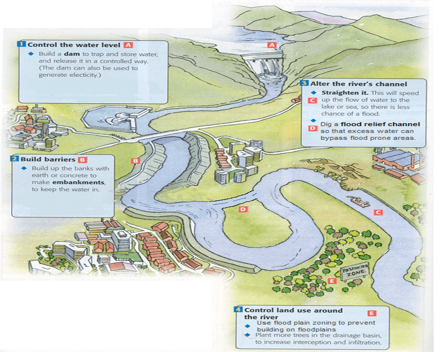
Hard engineering approaches include building a dam or embankments, straightening the river or digging a flood relief channel.
Hard engineering involves major construction to stop flood waters.
Soft engineering approaches include planting trees and flood plain zoning.
Soft engineering works with nature without major construction and may not actualy stop the flood but may reduce it.
CASE STUDY
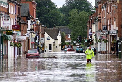
The River Teme has flooded Tenbury 17 times in the last 60 years.
In 2007 the River Teme was 5.97m – the highest level ever recorded. Flood water in the streets of Tenbury was 90cm deep.
The 2007 flood was caused by heavy rain being unable to infiltrate into saturated ground
Following these floods a soft engineering scheme was planned for Tenbury Wells.
The 2007 River Teme flood management scheme
There are 169 properties in Tenbury at risk of flooding. This scheme has cost £400 000 and has provided flood protection for 100 properties in the town – approximately £4000 per property.
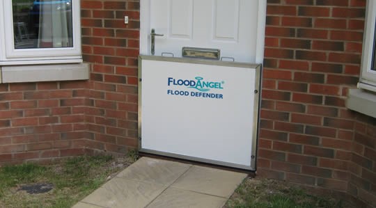 Flood boards are barriers that fit across doors and low windows. They have a rubber seal and are screwed in place. They are fitted when a flood is expected.
 Many properties flood when water comes up from flooding sewers and drains. One way valves have been fitted which stop water coming up toilets and drains and flooding a property.
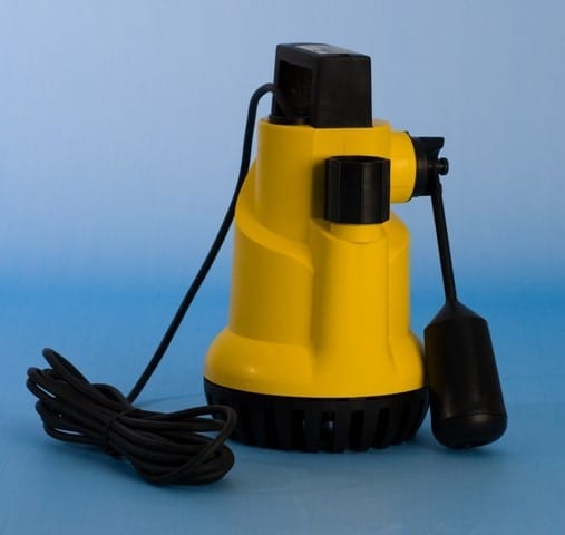 Properties with cellars and basements, like pubs in Teme Street, have been provided with a floating pump which automatically pumps out water if they flood.
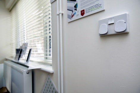 Several properties have had electric sockets raised to prevent damage to electricity supplies in a flood.
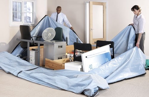
Many properties are now equipped with flood bags – very large thick strong zip up bags – into which a rooms contents can be packed if severe floods are predicted.
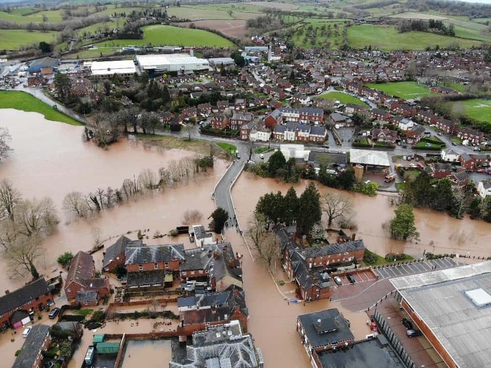
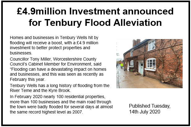
There was further flooding in October 2019 and February 2020. The River Teme reached 5.90m causing extensive damage.
The 2020 River Teme flood management scheme
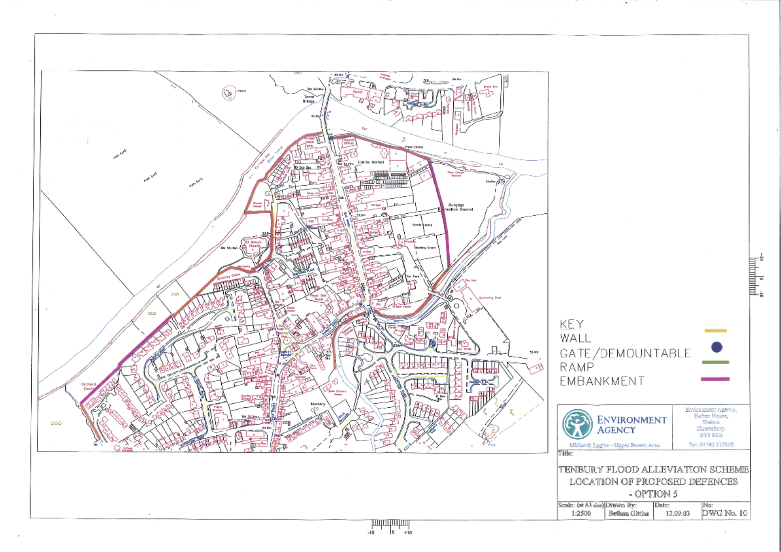 There is a plan for a new flood wall to surround Tenbury Wells and keep the water out. The planned route for the flood defences is shown on this map. It is estimated to cost over £5 million.
Who may be in favour or against?
Some groups of people will be in favour of soft engineering flood defences in Tenbury Wells. They include taxpayers because it’s cheaper than hard engineering. People with views of the river and fishermen might also prefer soft engineering because it looks more natural.
Some groups of people would prefer hard engineering flood defences. They include the shop keepers of Teme Street and residents of Church Road, who would prefer a flood wall or similar to prevent any future flood damaging their home or business.